

Monitoring Methods
Sediment
- Sediment Pins
- Sediment Plates
- Marker Horizons
- Surface Elevation Tables (SETs)
- Soil Characteristics
- References
Join the Discussion
Sediment Monitoring Methods
The goal of sediment monitoring is to quantify changes in sedimentation and soil characteristics that relate the changes in elevation, vegetation, and invertebrates.
Sedimentation
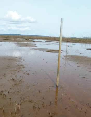
Sediment pin, Nisqually estuary.
The rate of sediment accretion or erosion is a determining factor of tidal wetland sustainability with sea level rise and a primary driver of habitat evolution over time. Accretion rates vary spatially due to many factors including elevation, vegetation type and productivity, distance to channels, wave climate, and salinity dynamics. Elevation of the mud flat and the associated inundation frequency and duration are critical to understanding the potential vegetation community that will colonize post restoration actions. In the context of climate change, long term adaptability and persistence of tidal marsh depends in part on sediment sources, quantities and distribution patterns. Basin scale restoration and enhancement projects, including the blocking of large naturally eroding bluffs, are projected to significantly reduce historical sediment delivery rates. In contrast, changes in the flow regime (e.g. dike removal) and in storm frequency and intensity may increase sediment delivery.
Multiple methods are used to measure sedimentation in tidal marshes and should be chosen based on restoration and monitoring objectives and site specific considerations. Thomas and Ridd (2004) provide a comprehensive comparison of many methods used to measure short time scale sediment accumulation. You can also find a breakdown of sediment deposition and accretion methods in the Comprehensive Everglades Restoration Plan (CERP) Quality Assurance Systems Requirements (QASR; CERP 2009).
Here we present information on the following methods for repeated measures of sedimentation at localized spots over time. For broader spatial coverage, we recommend referring to methods detailed on the Elevation webpage. To access more details and standard operating procedures, click on the method name below.
- Sediment Pins
Description: Poles installed within a study site. Height of pole is measured through time to show sediment gain or loss.
Benefits: inexpensive, easy to install and measure underwater or on land
Limitations: sedimentation rates limited to where pin is installed, cm resolution - Sediment Plates
Description: in areas of soft sediment, a hard plate is placed below the sediment surface. Measure sediment accumulation on top of plate.
Benefits: easy, inexpensive, possible to measure accumulation and erosion, reduces error of rod penetrating into soft sediments, mm resolution, can be used to calculate sediment volume
Limitations: plates can be undercut due to hydrologic scour - Marker Horizons
Description: A thick marker layer (usually white in color, i.e. feldspar clay) placed on top sediment surface. Sediment cores are later taken to measure sediment accumulation. Can be paired with Surface Elevation Tables (SET) to explain processes behind elevation increases or decreases (i.e. sedimentation, shallow subsidence, etc.).
Benefits: easy, inexpensive, mm resolution
Limitations: repeated measures can deplete marker horizon layer, can be affected by invertebrate bioturbation, does not measure erosion, can be eroded/washed away (typically in unvegetated areas, in this case, use of plastic grid or sediment plate is recommended), can be difficult to measure in areas of standing water (may need to freeze sediment core using liquid nitrogen). - Surface Elevation Table (SET)
Description: Portable mechanical leveling device for measuring relative sediment elevation changes. Is often paired with marker horizon to explain processes behind elevation increases or decreases (i.e. sedimentation, shallow subsidence, etc.).
Benefits: accurate and precise as measurements are always taken in the exact location, mm resolution
Limitations: expensive to install, sedimentation rates limited to where poles are installed, poles can sometimes cause erosion in unvegetated areas.
Soil Characteristics
The physical properties of soil (i.e. particle size fractionations) are important aspects of sediment transport models. In addition, soil attributes (i.e., soil texture, nutrient availability, and organic matter content) are key determinants of vegetative condition, invertebrate response, and avian foraging responses. Soils collected at strategic monitoring locations can provide information for models or biological responses. A known volume of soil can be sent to a laboratory to analyze for percent sand, silt, and clay or particle size fractionations, soil organic matter content, and nutrient availability. Observed changes in the vegetation community can be a result of soil salinity, especially in areas where specific species tolerances are near thresholds for growth. Pore-water soil salinity can be collected separately and measured in conjunction with salt marsh and tide flat vegetation surveys. Sample volume, collection, and storage methodology will be dependent upon desired analyses and laboratory specific guidelines.
References
CERP. 2009. Quality assurance system requirements (QASR) manual for the comprehensive everglades restoration plan (CERP). Available online at: http://www.evergladesplan.org/pm/program_docs/qasr.aspx (accessed 4 Jan 2012)
CERP. 2009. Quality assurance system requirements (QASR) manual for the comprehensive everglades restoration plan (CERP), soil and sediment sampling procedures chapter 7. Available online at: http://www.evergladesplan.org/pm/pm_docs/qasr/qasr_2009/qasr_2009_chap_07.pdf (accessed 4 Jan 2012)
CERP. 2009. Quality assurance system requirements (QASR) manual for the comprehensive everglades restoration plan (CERP), methods for in-situ surveys and physical measurements appendix 7b. Available online at:
http://www.evergladesplan.org/pm/pm_docs/qasr/qasr_2009/qasr_2009_app_07-b.pdf (accessed 4 Jan 2012)