

Habitat: Aerial Photography and Remote Sensing

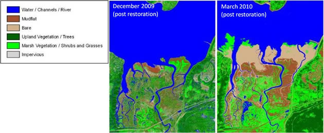
Aerial photographs pre- and post-restoration, Nisqually estuary
Aerial photographs are the basis for remote sensing applications and are valuable tools for the visual documentation of water drainage, channel development, vegetation colonization, and geomorphic change. Initial acquisition should be prior to restoration and if possible, photographs should be acquired annually thereafter for the first five years to document initial site response after restoration. False color infrared aerial photos should be taken during low tide at the peak of the growing season. Depending on the size of the site, multiple photographs will need to be tiled together to cover an area. Ensure that the image tiles overlap by 20% to develop a mosaic with the aerial images. Registered targets or landmarks placed at monitoring stations can be used to geo-reference aerial photographs. Otherwise, request that the aerial photography company mosaic and georeference the images to save time and maintain consistency. Ensure that aerial images will be of consistent pixel resolution (the on the ground area that is represented by 1 pixel seen on the screen,) so that changes seen in the aerial photograph are not due to changes in image resolution. Geographic Information Systems (GIS) software can be used to assess vegetated salt marsh coverage, digitize channels and assess channel development, and quantify spatial extent of land-cover types (with ERDAS Imagine or other software). Geographic Information Systems (GIS) software can be used to assess vegetated salt marsh coverage, digitize channels and assess channel development, and quantify spatial extent of land-cover types (with ERDAS Imagine® or other software).
Remote Sensing
We present three applications for remote sensing in tidal marshes:
Remote Sensing: Habitat Types
Habitat distribution can be assessed using aerial imagery containing a near infrared band and spatial software (such as ERDAS Imagine® and ESRI ArcGIS®) to classify, delineate, and digitize boundaries for the key estuarine habitats. Habitat distribution can be assessed using infrared aerial photographs and spatial software (such as ERDAS Imagine and ESRI ArcGIS) to classify, delineate, and digitize boundaries for the key estuarine habitats. Habitat classifications should be made based upon local vegetative community types and may include categories such as: eelgrass, low tidal marsh, high tidal marsh, freshwater wetlands, forested wetlands, upland and dike/levee. Habitat and community composition data collected during annual vegetation surveys (see Vegetation), as well as personal site knowledge can be used for ground-truthing and refinement of the spatial extent of each habitat classification.
Click here for methods to create land cover classifications using ERDAS Imagine® and ESRI ArcGIS® [ 7.8 MB PPT ]
Aerial Photography Habitat Classification Slideshow »
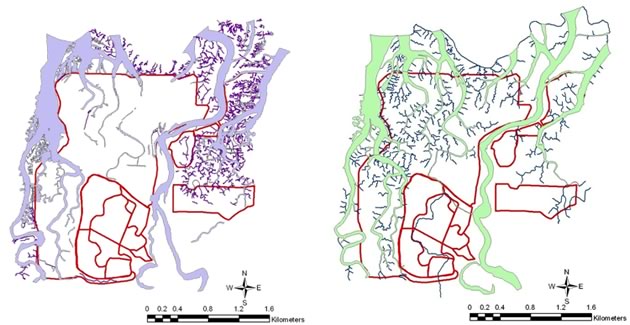
Remote Sensing: Channels
To document changes in channel allometry such as formation and movement, use low-tide aerial photographs and ArcGIS® to digitize the width and length of visible channels. For higher resolution channel mapping, the site may be mapped on foot using a GPS and additional channels can be further digitized and classified by channel order within ArcGIS®. For comparisons between years, a consistent scale of resolution is necessary so that change detection is based on observed differences rather than different detection ability.
Remote Sensing: Large Woody Debris
Woody debris refers to fallen trees, logs, stumps, and root wads that can be transported from upstream sources and deposited within an estuary. Large woody debris (LWD) provides important habitat structure for fish and other estuarine species, and can change water flows, velocities, sediment transport. Furthermore, the decomposition of LWD can support significant invertebrate prey resources for fish and other aquatic species and provide channel and streambank stability in low gradient streams. Accumulations of LWD may form logjams that span the entire width of a channel. These natural occurrences usually do not impede fish passage, rather can create backwater conditions and pools that can be beneficial in creating new channels. LWD can be difficult to define because it largely depends on the habitat or hydrologic significance. Nonetheless the Washington Department of Ecology defines LWD as logs that are > 10cm in diameter and at least 1m long (Janisch 2006). However, to track the size and movement of LWD by digitizing them on aerial photographs, the size of LWD may need to be adjusted to a larger size class.
Large woody debris can be monitored with remote sensing from annual aerial photographs. Visible LWD is located and delineated on a georeferenced image. The imagery will be analyzed to assess changes and movement associated with the location and functions of the LWD (i.e., log jam, creating pools reducing channel flow, facilitating new channel development). To best digitize LWD using aerial imagery, be sure to analyze high resolution aerial imagery.